TAFs are so last century—here are four new tools to try
Air Facts Journal
If your preflight weather briefing habits don’t change every few years, you probably aren’t curious enough. Occasionally there are major shifts, like the one from Flight Service phone calls to iPad app self-briefings, but more often we slowly integrate new weather resources and let others fade away. That’s exactly what I’ve done with the Terminal Aerodrome Forecast (TAF), the gold standard of aviation forecasts. I still take a look, but it plays a much less central role in my decision-making process than it did five years ago.

The familiar TAF is still useful, but needs to be supplemented by other forecasts.
Nothing has really changed with TAFs, but maybe that’s exactly the problem. They are still issued four times per day, in the same infuriating format that was first invented for telex machines half a century ago. Sure, an iPad app can translate that code (and those of us who learned to fly before 2000 can even speak fluent METAR/TAF), but why should they have to?
More importantly, the rigid format of the TAF limits the value of the forecast they provide. A TAF is exactly what it says, an aerodrome forecast, so it’s limited to conditions within five statute miles of the airport. That means it won’t offer much help if the world is ending 10 miles to the west in heavy rain and hail but the airport is clear. And of course there are thousands of airports with no TAF at all. As you may have noticed, weather happens in between TAF locations.
The TAF also has no room for uncertainty or suggesting multiple scenarios. If rain might move in at 1200Z but the forecaster is also considering snow at 1300Z, too bad. The final TAF will probably be quite explicit one way or the other. It’s not the forecaster’s fault, it’s just what the format demands.
The other problem with TAFs is their limited forecast period: 24 hours for most airports, but out to 30 hours at some larger airports. That’s not all bad—a detailed forecast like a TAF probably wouldn’t be worth much at 72 hours—so the limitation is hardly arbitrary. But sometimes it’s helpful to know what the day after tomorrow might be like, at least in general. Low IFR with gusty winds or severe clear? Sometimes a hint is enough to help a GA pilot plan.
While I’m being hard on the TAF, it’s mostly doing its job. And to be clear, TAFs are created by experienced forecasters with local knowledge. They are far more than a data puke from a computer model, and should be read that way. But the fact is, we have access to more and better tools now.
Forecast discussion
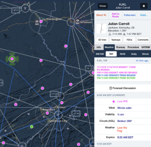
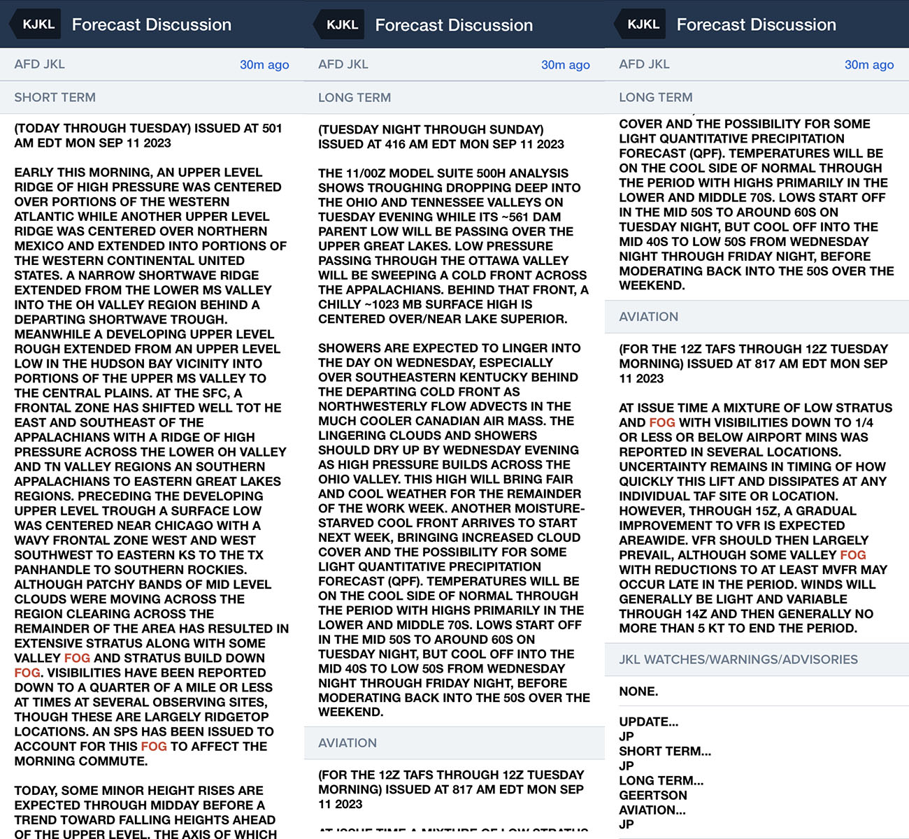
First up is the forecast discussion, a textual product that is now available in most electronic flight bag apps. This is a fantastic complement to the TAF, because it allows the forecaster room for uncertainty and context. It also stretches out a full week, at least for the broader parts of the forecast. If the TAF is the play-by-play announcer, the forecast discussion is the color commentator (but not quite as annoying as Tony Romo).
If you read one, you’ll notice there is an aviation-specific section with details on ceilings and visibility. This is very valuable, but don’t skip over the other parts of the forecast. You can learn a lot about how the forecaster arrived at their conclusions by reading about concepts like short waves and troughing aloft. Even if you don’t know what all that means, it’s a great way to learn about how forecasts get made.
The Forecast Discussion provides a lot more human perspective than the TAF.
I always note what the forecaster is looking at, because if those big picture trends change then I’ll know to be suspicious of the overall forecast. For example, if good visibility is expected due to high overnight low temperatures but you notice temperatures are dropping quickly, then you should be on the lookout for fog. The assumptions underlying the forecast are not holding, so the forecast might not either.
Forecast discussions can vary in style depending on the forecaster (whose name is usually at the end), but the best ones read like great short stories. In particular, you can sometimes see the meteorologist struggling with whether to include a weather phenomenon in the TAF. One recent one read, “Widely scattered showers are likely to develop over central OH, but kept out of the Columbus TAFs due to low probability.” That’s great information for a VFR pilot flying to Columbus—at least you know how things might go wrong.
Graphical models
For pilots interested in a more visual weather product, there is a flood of graphical weather models now available online, which are essentially computer simulations of what might happen in the future. Most aviation apps don’t offer these, but sites like Pivotal Weather are easily accessible and free. The navigation can be confusing due to the huge number of options, but it’s worth the effort. First click on Models in the top menu, then choose one from the top of the map (blue button next to Model>). Once you’ve selected a model, you can choose which map to view (precipitation, temperature, etc.) from the left side menu, then choose the Forecast Loop option from the Animation> menu so you can see the trend developing over time.
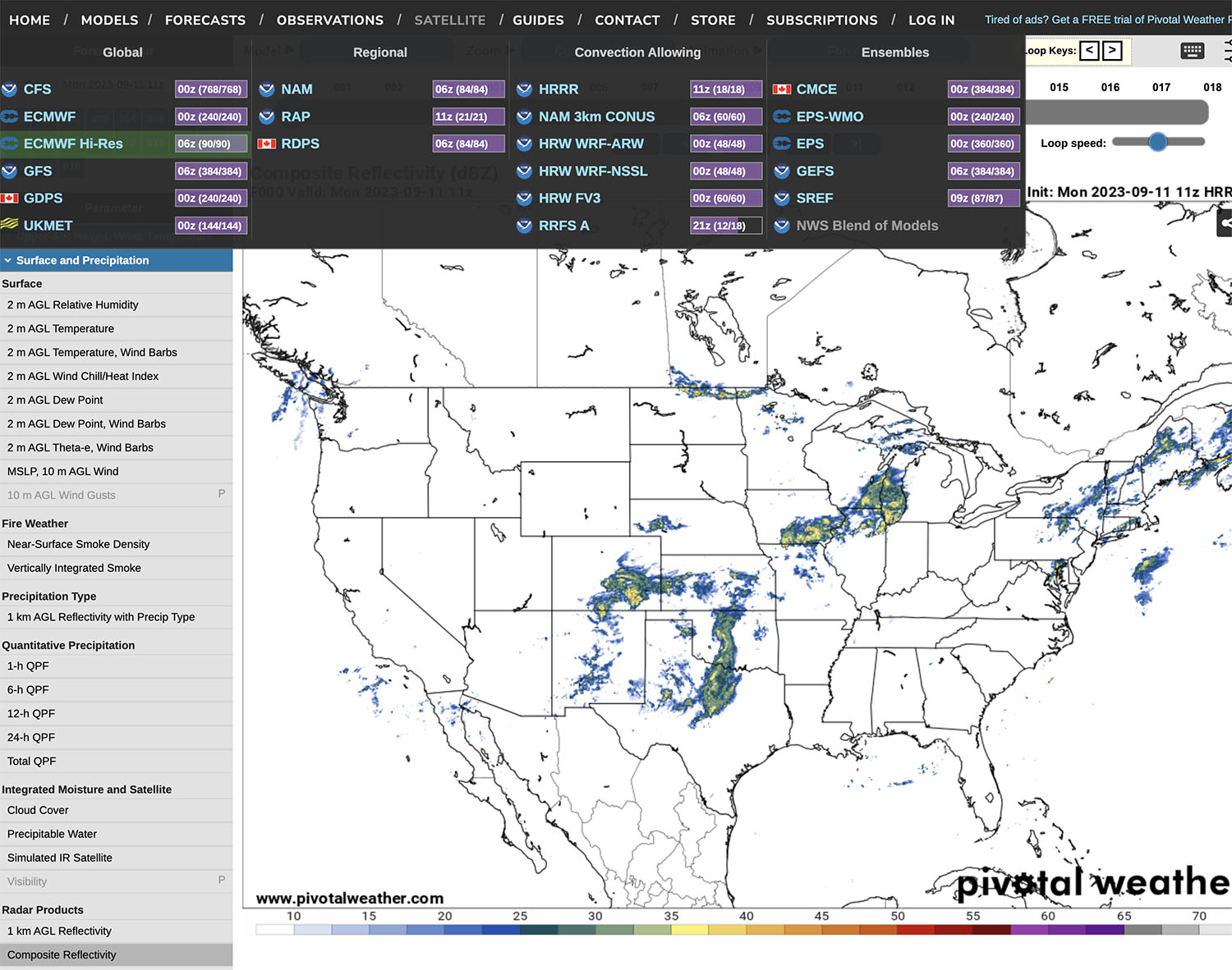
There are plenty of models to choose from: the GFS and HRRR are two to start with.
Meteorologists will argue over what the best model is, just like pilots love to argue about the best airplane. The truth is, in the same way a Carbon Cub is not the perfect airplane for every mission, each model has its strengths and weaknesses. Two in particular that I look at are the High-Resolution Rapid Refresh (HRRR) and the Global Forecast System (GFS). The HRRR is a shorter range forecast (typically 18 hours, but four times a day it goes out to 48 hours) and is highly specific about rain and even convection. You can choose simulated reflectivity to see a “forecast radar” map and animate it to see hourly changes. This is tremendously helpful for visualizing how rain or storms might develop, and always something I look at if I’m trying to plan the best departure time.
It’s worth emphasizing that this is a model, so just because the HRRR shows no storms at your departure time 24 hours in the future does not mean you are guaranteed a smooth flight. This should be backed up by a look at the surface analysis, satellite imagery, TAFs, and all kinds of other weather products. It’s also worth noting how well the 0-hour forecast matches current conditions—if the model has a bad starting point, it may not get better. Having said that, I have found this model to be quite accurate in recent years. Here’s an example of an HRRR simulated reflectivity image for 29 hours out:

And here’s the actual radar image:

Not bad for planning possible scenarios for a flight tomorrow.
The GFS model is not as precise as the HRRR—the simulated reflectivity layer is not quite as detailed and the forecast resolution is 3 hours—but it goes out 16 days in advance. I use this model for longer range planning: should I come home next Saturday or Sunday? The GFS can’t give you a black and white answer, but it can suggest when a big front might be moving through. If nothing else, it helps to refine the next steps in your planning.
Model Output Statistics
Another way to look at models is with the textual Model Output Statistics (MOS), which are essentially a text version of the models above (meteorologists: I know it’s a little more complicated, so don’t send hate mail just yet). These have been around for decades, but in recent years they have found their way into aviation apps because they are available for over 1500 locations—many more than the number TAF sites. In ForeFlight, for example, tap on an airport and go to the weather section, then MOS. The app decodes the text into an easily readable format, including wind, visibility, ceiling.

MOS forecasts are available in most EFB apps, like ForeFlight.
No human is involved in a MOS and the predictions are mostly categorical (visibility of 2 miles probably means IFR, not literally 2 miles), so don’t make the mistake of reading one like a TAF. They are also not a replacement for a TAF when it comes to alternate airport planning. But a MOS is a helpful resource at remote airports, and the forecast goes out to three days. The key is to focus on the trend (are ceilings coming down tomorrow afternoon?) instead of specifics (what will the wind be at 1800Z?).
Graphical Forecasts for Aviation
While I do most of my preflight planning in ForeFlight or Garmin Pilot, for challenging flights it’s definitely worth visiting AviationWeather.gov . This has recently been upgraded to be much more modern and interactive (although there are a few quirks to learn). The most valuable tool is the Graphical Forecasts for Aviation (GFA), which provides forecast maps for precipitation, clouds, turbulence, icing, and much more.
For VFR pilots, the forecast cloud map is particularly helpful. This is an easy-to-read depiction of cloud bases and tops, in one-hour increments out to 18 hours. At a glance, you can tell whether that cloud layer is low and thick or just high level cirrus. Likewise, it’s easy to see how widespread clouds might be, and whether a new route might keep you clear of them. For IFR pilots, the cloud tool is great for staying out of ice: can you get on top or will you be slogging through below-freezing clouds?
Don’t forget the 4D element of this tool. By using the slider bar at the bottom, you can see how clouds change over time. Often the go/no-go decision comes down to “when should we go?” The GFA map is ideal for testing out different scenarios.
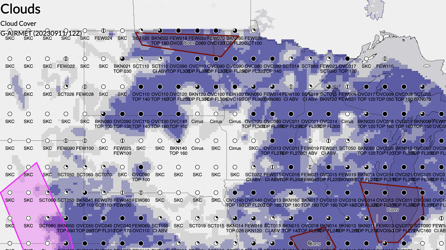
The cloud forecast chart is a great way to play VFR flights.
Use all the tools
To be clear, I’m not suggesting pilots ignore TAFs. If a professional forecaster is calling for low IFR conditions at your destination all day, that’s a strong hint that a VFR flight for a $100 hamburger is a bad idea. But neither should pilots rely solely on a TAF for preflight planning—it’s like trying to understand the world around you by looking through a periscope.
Fortunately for pilots, there is a whole new world of weather tools out there, available for free on your phone or tablet. Learn how they work and use them. They can absolutely help you fly more safely, but at the very least they can reduce some preflight stress.
The post TAFs are so last century—here are four new tools to try appeared first on Air Facts Journal .